Top Things To Do And Places To Explore In The Vermilion Cliffs National Monument

Nestled in the rugged red rock landscapes of Northern Arizona, the Vermilion Cliffs National Monument stands as a testament to nature's awe-inspiring beauty and power. This is a remote location that I have explored dozens of times over the last 25 years and its one of my personal favorite spots to visit and play in the American Southwest. From its towering red rock namesake cliffs to its expansive high desert plateau, this area offers an array of outdoor activities to do and stunning locations for visitors to explore. Whether you're an avid hiker, photographer, angler, or simply a nature enthusiast seeking some solitude, here are some of the top activities and places I recommend checking out when visiting Vermilion Cliffs National Monument and the immediate surrounding area.
Marble Canyon, Arizona:
In my mind, the small and remote high desert community of Marble Canyon is the gateway to the Vermillion Cliffs monument and wilderness areas. Situated along beautiful highway 89A, the first stop I would recommend just as you enter Marble Canyon is the Navajo Bridge interpretive visitor center. This historic bridge, originally opened in 1929, is actually located in the Glen Canyon Recreation area and it features pedestrian access to the old bridge which parallels the new bridge. Here you can walk out onto the bridge and enjoy jaw dropping views of Marble canyon and the mighty Colorado river nearly 500 feet below- see images below. In addition, views of the nearby and towering Vermillion Cliffs are available and impossible to miss. And if you are lucky, you may also get to see a few rare California Condors that like to hang out in the rafters of the bridges. The largest winged bird in North America, these birds are a sight to behold when they dive and soar over and under the bridges. See images below.
Marble Canyon Amenities:
Along highway 89a in Marble Canyon there are a few gas stations with convenience stores, lodges, and restaurants. If you are looking for a great restaurant for breakfast, lunch, or dinner, I would highly recommend Cliff Dwellers Restaurant which is about 10 minutes away from Navajo bridge on the right side of 89A heading North. I have personally dined there dozens of times and the food is amazing and consistently good. This well-known establishment has a cool and laid back “old west” vibe in my opinion and the covered patio has excellent views. In addition, they serve great Margaritas, burgers, and wings too!
Hiking To The Wave
One of the most iconic features of the monument, The Wave is a surreal sandstone formation renowned for its undulating patterns and vibrant warm colors. Its a 6 mile round trip hike to reach the Wave, but to be honest, I have still not had the opportunity to visit this geological wonder. And that is not due to a lack of trying! Because of its crazy popularity as a photography subject, the park service or BLM actually only allows about 60 people a day to visit this wilderness area and for that you need a permit. Over the years I have submitted to the online lottery system (there is a $9 non-refundable fee) they have to issue permits at least 4 times now with no success. I have been told I would have a better chance of success if I just submitted for a slot for myself instead of a group of 2 or 3 people. I will keep trying of course and may even try the updated “daily permit” system if I am staying in the area for a few days- You have to be in a specific “geofenced” area in Northern Arizona or Southern Utah to submit one day in advance of the day you want to hike. You can find a lot of great and very detailed information here about hiking and photographing the Wave here.
Exploring White Pocket
Unlike the Wave, no permit is required to visit the other worldly and swirling White Pocket geological formations. However, the challenge is getting to this very remote location via a maze of very rugged and old ranching roads on a Plateau. You will absolutely a need a 4 wd vehicle or truck with high clearance to navigate the deeply rutted and sandy roads. I can share with confidence that the effort is worth it and this is one of the most unique and bizarrely beautiful geological formations I have ever seen- see images below. There is really no organized trail through this wilderness area, but its fun and relatively easy to transverse and explore the rocky terrain.
Photography: With the incredible diversity of textures and sweeping views the landscape photography opportunities at White Pocket are needless to say incredible. I am personally looking forward to getting back there to capture some images closer to sunrise or sunset time- the golden hours.
Drones: For Drone video and photography enthusiasts like myself, this is one of the few locations in the Vermilion Cliffs Monument where you are actually allowed to launch a drone from what I have researched. I would just advise you to be respectful of other visitors and keep your flights relatively short.
Exploring Coyote Buttes South
As with the Wave which is located in Coyote Buttes North, you will also need A permit to walk in and explore Coyote Buttes South. Although I have not had the chance to explore it yet, I have driven right past the designated entrance and the swirling red rock formations (they kind of look like red snow cones) are surreal looking. See images below. I read recently that the Bureau of Land Management (BLM) has also instituted geofence system for getting daily lottery permits to hike in Coyote Buttes South area that is located in the Paria Canyon-Vermilion Cliffs Wilderness area.
Adjacent Areas To Explore While Visiting Vermilion Cliffs Monument
If you are an angler or just want to see the Colorado river, I would highly recommend you visit the very close by Lee’s Ferry Recreation Area. This is one of the few spots for several hundred miles you can actually walk or hike along the river banks of the mighty Colorado river with the towering Vermillion Cliffs in the background. A good location to walk along the river is Paria Beach where there is a large parking lot and a restroom. Paria beach is near the inlet of the muddy and often chocolate shake colored Paria River. Another location to get close to the river is the famous boat ramp where the majority of rafting expeditions begin their journey down the Colorado river into Grand Canyon National park.
Kayak The Colorado River: If you really want to experience the legendary Colorado river up front and personal, I would recommend you rent a Kayak and get backhauled up river about 9 miles or so and then float or paddle back down to the boat launch at Lee’s Ferry. This is an affordable adventure and the epic and scenic boat ride up river alone is worth the price of admission. Licensed and local backhaul outfitters like KayakHorseshoeBend.com make setting up this unique experience seamless and lots of fun.
Go Trout Fishing: The Colorado river at Lee’s Ferry is a world famous Rainbow trout fishery due to the crystal clear and cold water that emerges from the bottom of Glen Canyon Dam 15 miles upriver from the Lee’s Ferry boat launching area. Whether you fly-fish or spin cast, there is plenty of accessible water to fish in the well known and public walk-in stretch of the river which can be reached from hiking in from one of the few pullouts along the Lee’s Ferry access road or river drive. Another very popular option is to hire an experienced fishing guide and jet boat up river to fish. Local guiding services like Lee’s Ferry Anglers have a full staff of professional guides who can work with anglers and fly fishers of any experience level.
Hiking Opportunities: There are a number of easy to challenging hiking trails in the Lee’s Ferry Recreation area. An easy and very scenic trail is the “River Trail” that begins a the end of the large gravel parking lot at the Lee’s Ferry boat launch. This trail sits above and parallels the river and passes some historic and interesting structures. A much more challenging trail and hike is the “Spencer Trail” which is accessed off the aforementioned “River Trail”. This rugged and rock trail switch backs its way up a steep canyon wall and offers incredible and panoramic views. If you have a fear of heights, this is probably not a good option for you!
Pioneer History: There are number of historic building and ruins in Lee’s ferry that are worth checking out and are also great photography subjects. A few of them can be prominently found near the large gravel parking lot at the boat launch area. The historic Lonely Dell Ranch is also nearby and even has an active fruit orchard. This very shaded and green oasis in the red rock desert is a great place to have a picnic.
Stargazing: The Vermilion Cliffs National Monument and surrounding area are also well known as a popular stargazing destination because its remoteness and clear desert skies. Im not an expert in this field, but as someone who has camped out in this area many times I can validate that the night skies here are truly amazing.
Best Time To Visit?
My favorites times of the year to visit Vermilion Cliffs National Monument is early spring, late fall, and the winter months. The summer months are just a little bit too hot for me now and I prefer being up in the mountains and high country that time of year. As far as winter, with elevations ranging to 3,500 feet to over 7,000 feet it can get a little chilly there in the winter months. But this is also one of the few times of the year where you literally can have the place to yourself. And with the brilliant high desert sunlight of the American Southwest, even 40 degrees can be very uncomfortable to hike around in during the day. And if you are really lucky and time it right, you may even have the opportunity to see the Vermilion Cliffs dusted with snow which is a sight to behold.
In Summary:
Vermilion Cliffs National Monument and the surreal and unique geological formations contained within is a haven for outdoor enthusiasts, offering a wealth of adventure opportunities amidst its stunning and powerful landscapes. Whether you're seeking thrilling and uncrowded hikes, captivating Southwest landscape photography opportunities, or simply a moment of solitude in nature, this unique destination promises an unforgettable experience without the big crowds of tourists found at other more well known parks in Northern Arizona and Southern Utah.
Images & More Info:
Below are a few photos I have captured in the Vermilion Cliffs National Monument area over the years. Please feel free to contact me if you have any questions or special requests for image and video content. All images and video content are copyrighted.
Other Popular Blog Posts:
Where To Find Snow In Sedona?: View info about the best locations in my experience to see snow in Sedona during the winter season.
Slide Rock State Park: View a new blog post here about whether Sedona’s famous Slide Rock State Park is worth the effort.
Arizona Wild Horses: View info about my favorite locations to see the Salt River Wild horses
Image And Video Licensing: Visit here for info about my Arizona photo and video licensing opportunities
Creative Editing Services I Offer:
Photo Repair & Restoration: View info here about my old photo restoration services. This is a great way to digitize and preserve your old memories.
Video Editing: View info here about my affordable video editing services
Image Editing: See info about my affordable image/photo editing services
The snow dusted Vermilion Cliffs in Marble Canyon parallel lonely desert highway 89A which leads to the North Rim of the Grand Canyon near Jacob lake. .
The cliffs near the beginning of the Cathedral wash trail in the Lee’s Ferry recreation area.
A short video clip featuring some time-lapse scenes of moody weather in the Vermilion Cliffs area.
The Navajo Bridge Interpretive Center in Marble Canyon with the Vermilion Cliffs in the background.
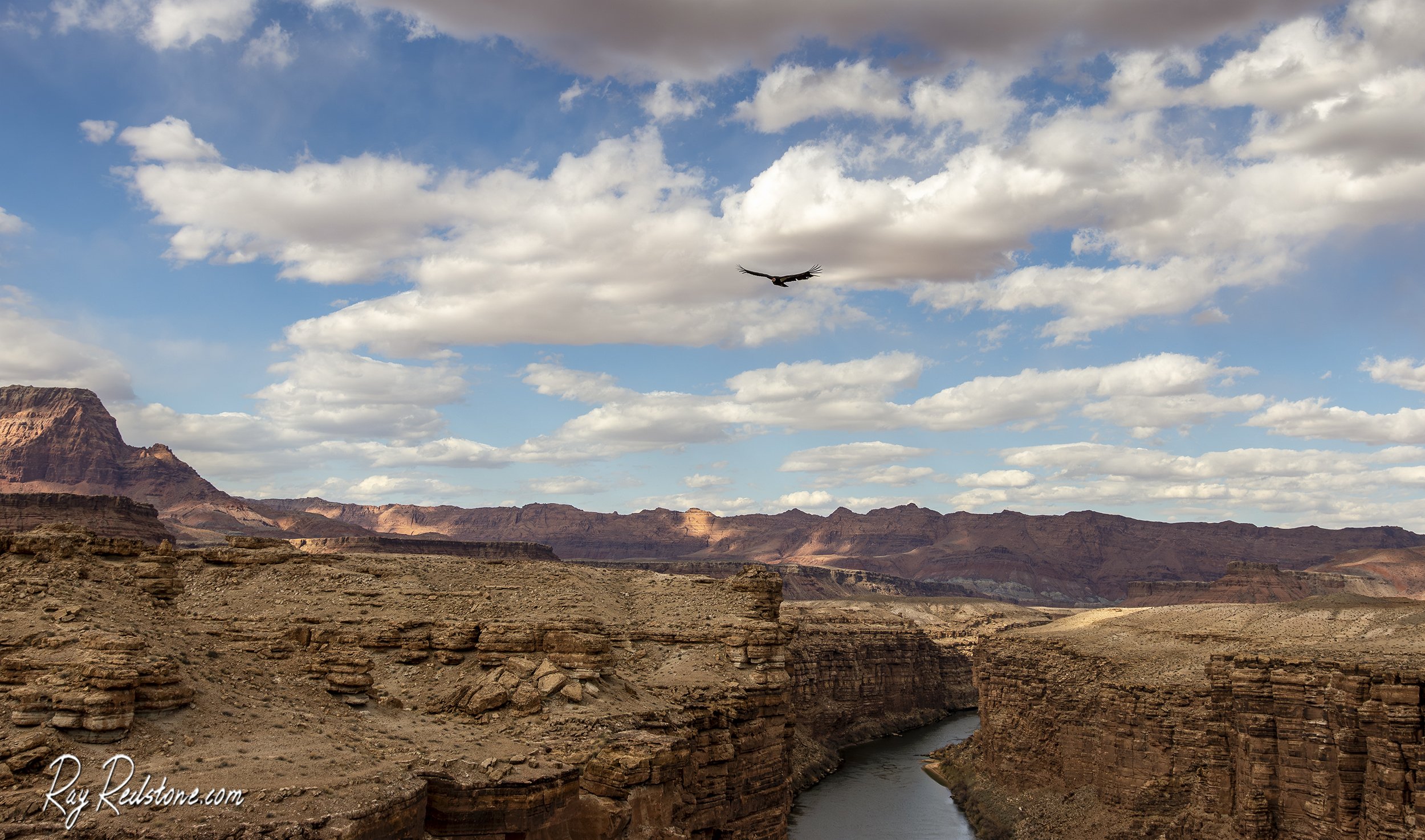
A rare California Condor soaring near Navajo Bridge in Marble Canyon. If the conditions are right, these big birds will put on quite a show dive bombing in and around the bridge.
This is one f the views of the Colorado river from Navajo Bridge.

Remote view of the Colorado river in Marble Canyon.
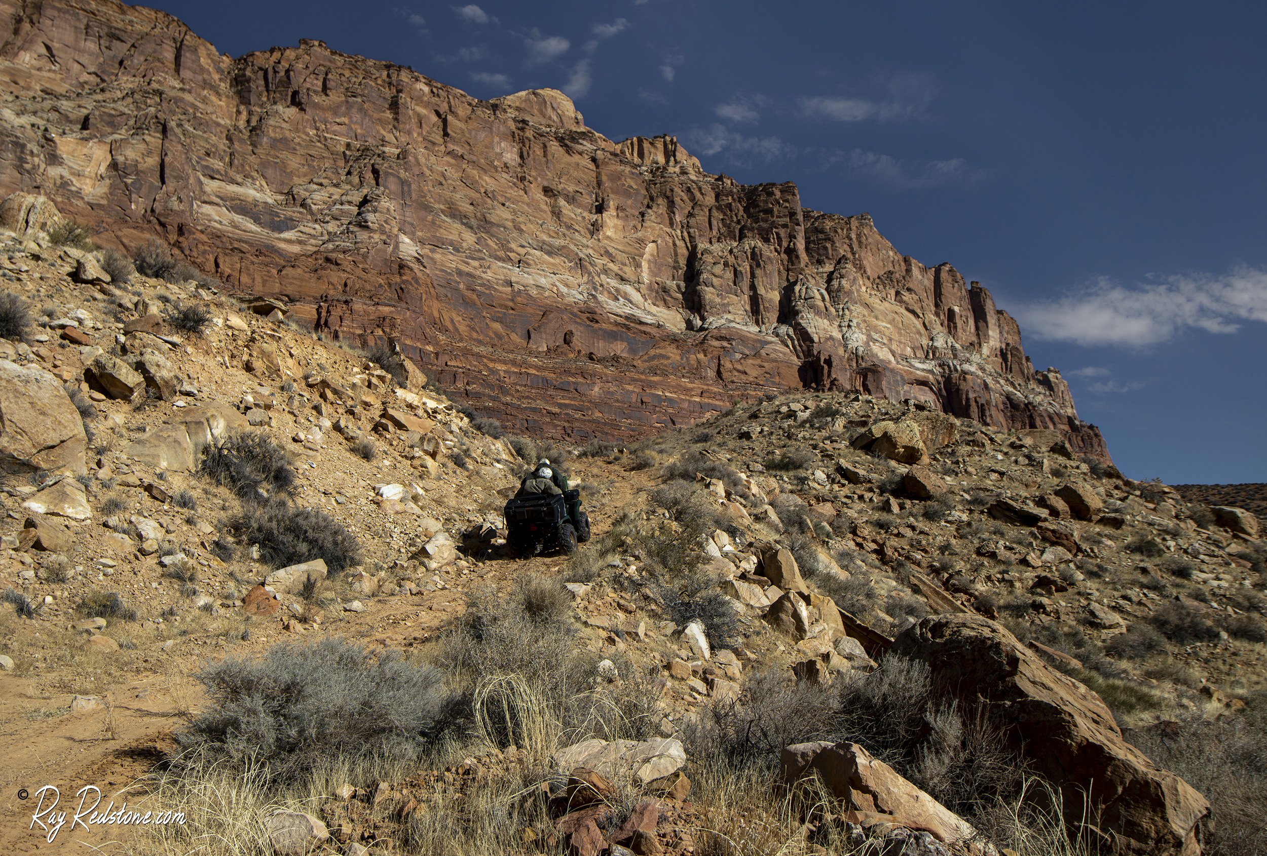
On a rugged adventure heading up into the upper reaches of the Cliffs.
Exploring the remote and upper reaches of the Cliffs on ATVS with some friends. Its other worldly up there with some surprising attractions!
One of the many alien rock formations at the remote White Pocket formation on the Paria plateau in the Vermilion Cliffs monument.
White Pocket “Brain” rock formation.
Swirling rock formations at Coyote Buttes South.

A friend of mine fly-fishing on the Colorado river at the Lee’s Ferry “walk-in” section with the towering Vermilion Cliffs in the background.
A very short video hopefully demonstrating the The Colorado river at Lee’s Ferry is one of the most beautiful places to fly-fish in the American Southwest.
This is your view from the first section of the challenging Spencer Trail near Lee’s Ferry. The much easier and equally scenic River trail is directly below. Wild or feral horses can often be seen along the far right river bank.

Colorado river canyon wall reflection up river from the Lee’s Ferry boat launch. Please contact me if you have any questions or requests for content.