Driving Tips For Schnebly Hill Road In Sedona
Introduction:
Nestled in the breathtaking red rock landscapes of Sedona, Arizona, lies a famous and rugged4 WD road that embodies the spirit of Southwestern adventure: Schnebly Hill Road. This iconic route not only offers stunning panoramic views but also holds a rich history that adds to its allure. In this blog post, I will share some tips about driving on this famous route into the town of Sedona. I will also share my blunt opinion that this adventure is not for everyone and that having a high clearance and four wheel truck is must when travelling up or down this rough and rocky road.
Schnebly Hill Road traces its roots back to the late 19th century when it served as a crucial transportation route for settlers and pioneers. Named after the famous Schnebly family, who played a significant role in the development of Sedona, this road was initially a wagon trail connecting Flagstaff to Sedona. Its construction began in the 1800s, with the aim of providing access to the fledgling town and supporting its growth.
A Bumpy & Challenging Route:
Fair warning: This road should only be engaged with a high clearance 4 WD truck or off-road vehicle. Its not suitable in any shape or form to travel on in a standard automobile or passenger vehicle. You will not make it and will likely have to try to turn back or possibly even abandon your vehicle. After my last ride on this road 2 years ago, I have serious concerns that even most popular SUVs would have a very difficult time making it down or up.
Why isn’t Schnebly Hill Road better maintained or graded? My guess is this is another conscience decision by the Forest service to keep visitors and vehicle traffic on this Sedona access road to a minimum. Because the popularity of Sedona as a travel destination never seems to wane this road would probably be extremely crowded and backed up with vehicles if it was too easy to negotiate. In addition, im sure the local tour companies that offer jeep trips up this road are just fine with that decision as well as this a very popular choice for a half day jeep tour.
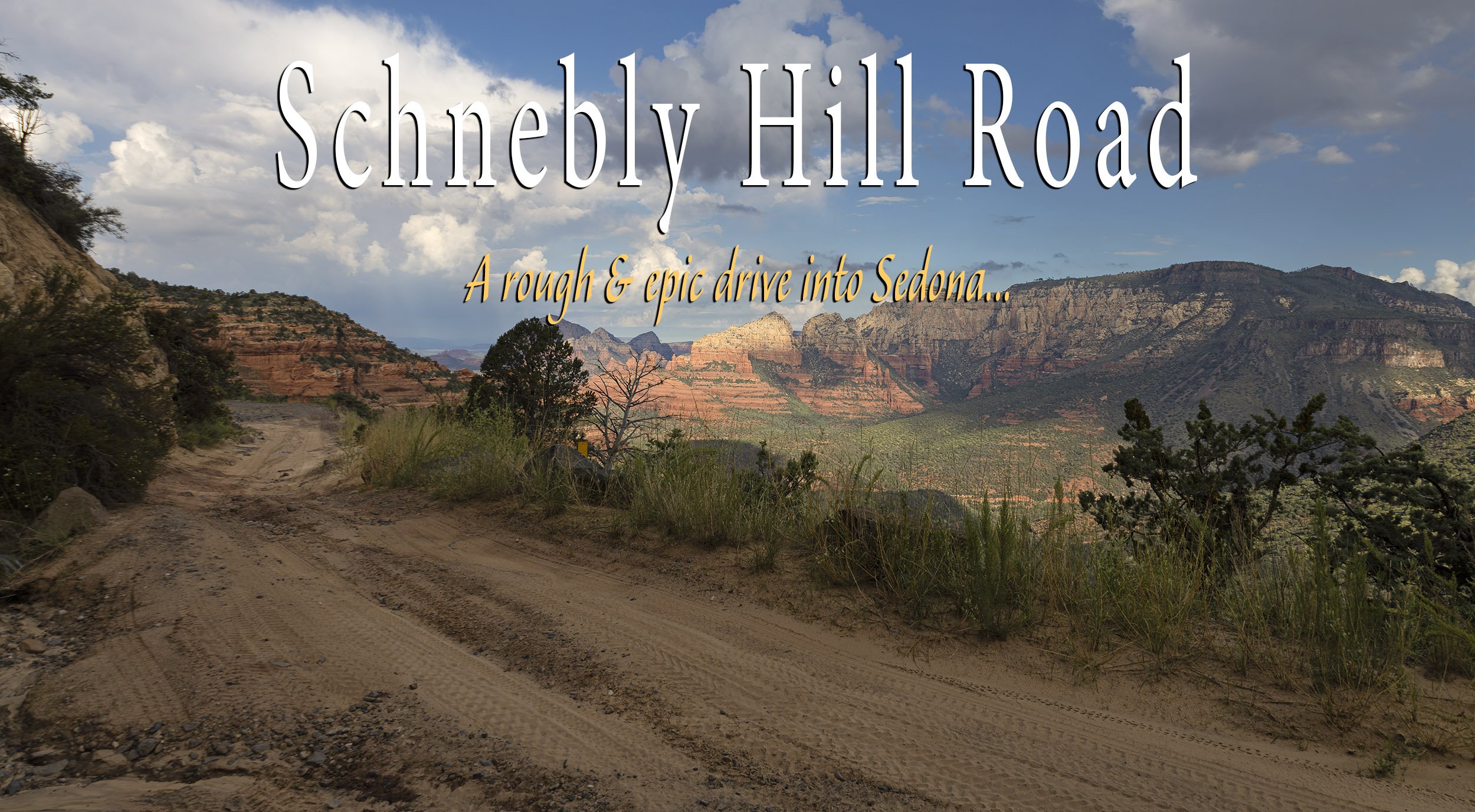
That being said, as you venture along Schnebly Hill Road today in an appropriate vehicle, you can't help but appreciate the engineering marvel it represents. The road stretches for approximately 12 miles, descending from an elevation of approximately over 6,000 feet to approximately 4500 feet in elevation. Its rugged terrain, steep switchbacks, and rocky surface demand skillful driving and patience. But, intrepid travelers are rewarded with breathtaking views of the surrounding red rock landscape and Sedona below.
The Schnebly Hill Road Vista or Overlook:
A must visit and stop for panoramic views of the surrounding landscape is the overlook pullout at the top of the hill- see images below. Here you will find a rough parking area and a clear path to walk out to the edge of the steep overlook to take in the sweeping views all the way to the Verde Valley and beyond. This is in fact the spot where the most jeep tour companies end their journey ascending Schnebly Hill road so there is a good chance you will not be alone between 830 am and 5pm…
If you arrived at The Schnebly Hill overlook via forest road 153 off Highway I-17, this is also a good spot to make a decision about whether your vehicle is suitable to make it down this very rugged road into Sedona. Its starts getting bumpy and challenging shortly when heading down the hill from the vista overlook so its a good time to turn back.
Other Landmarks and Points of Interest:
Along the journey, several notable landmarks and points of interest await exploration. Near the top of Schnebly Hill Road, you'll find the Merry-Go-Round Rock, a distinctive formation that resembles a giant carousel. Further down you will see the famous Cow pies rock formation. Additionally, there a few popular hiking trails that begin at Schnebly Hill Road trailhead which is near bottom of the hill. This paved pullout also has some good views as well as restrooms and a few picnic tables. The trails you can access there include the Munds Wagon trail, The Huckaby trail, and Margs Draw trail.
Tips for a Safe and Fun Adventure:
Before embarking on a trip along Schnebly Hill Road, it's essential to be prepared. One of the most important tips I can share with you is that this road is not always open. So first thing you may want to do is make sure the road is in fact open. I have found it closed many times over the years mostly due to weather related events like snow and heavy rain. I generally call the very helpful Sedona visitor center on highway 179 to inquire about the status of the road if I plan to take it down into Sedona. Checking the road status can save you a lot of time and gas as you will avoid the 30 minute drive up and past from the primary Sedona access road (Exit 279) to the Schnebly Hill Rd exit off interstate 17. When the road is closed the forest service places a chain gate and sign at both ends of the road.
Additional common sense tips include to pack sufficient water, snacks, and necessary safety equipment. Stay aware of weather conditions, as heavy rains (particularly during the summer monsoon season) can make the road treacherous with flash flooding. Always practice Leave No Trace principles and respect the fragile desert environment.
Please contact me if you have any special requests, questions, or want to purchase a Sedona photo or footage that is not linked. All images & video footage are copyrighted!
Some Other Services I Offer:
Photo Repair & Restoration: View info here about my old photo restoration services. A great way to digitize and preserve old memories.
Video Editing: View info here about my affordable video editing services

A stunning red rock landscape view awaits you off of Schnebly Hill Road…

This is one of the views from the Schnebly Hill vista or overlook at the top of the hill. Here you can see Monsoon summer thunderstorms forming at morning time in the distance.
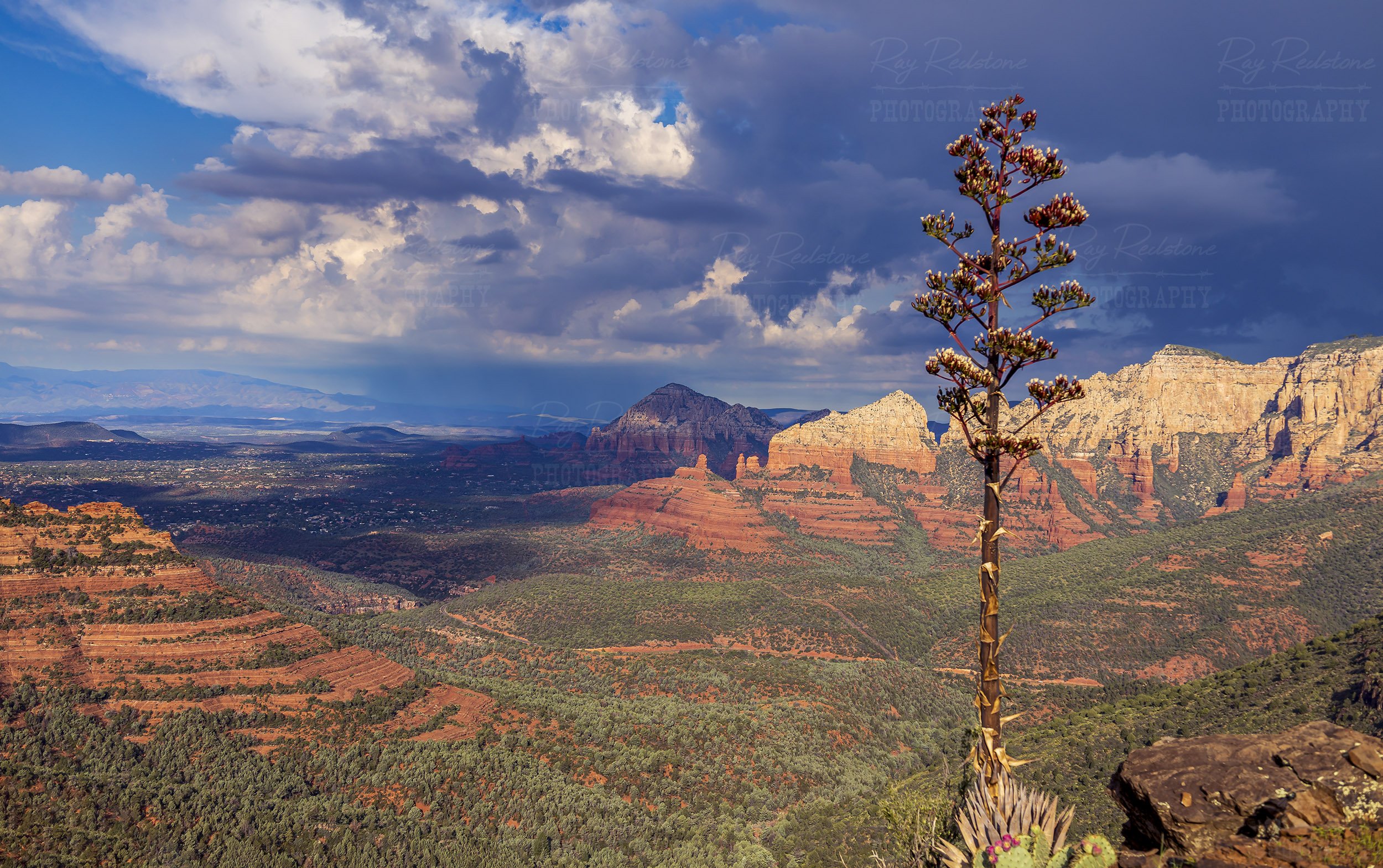
Another view from the overlook featuring a century plant.
Ray standing at the far end of the overlook. You can see the road descending in the background.
A view of the rough and rocky road as it start its descent from the Vista overlook.
Another view of Schnebly hill road as it continues its descent…
This a view from the Schnebly hill road trailhead near the bottom of the hill. If the road is closed for whatever reason it will be right after this pullout which provides access to a picnic area, a few hiking trails, and restrooms.